My QSO distances
I want to see what distance I have crossed with my QSOs, in what direction and when. All separated by band.
Table of Contents
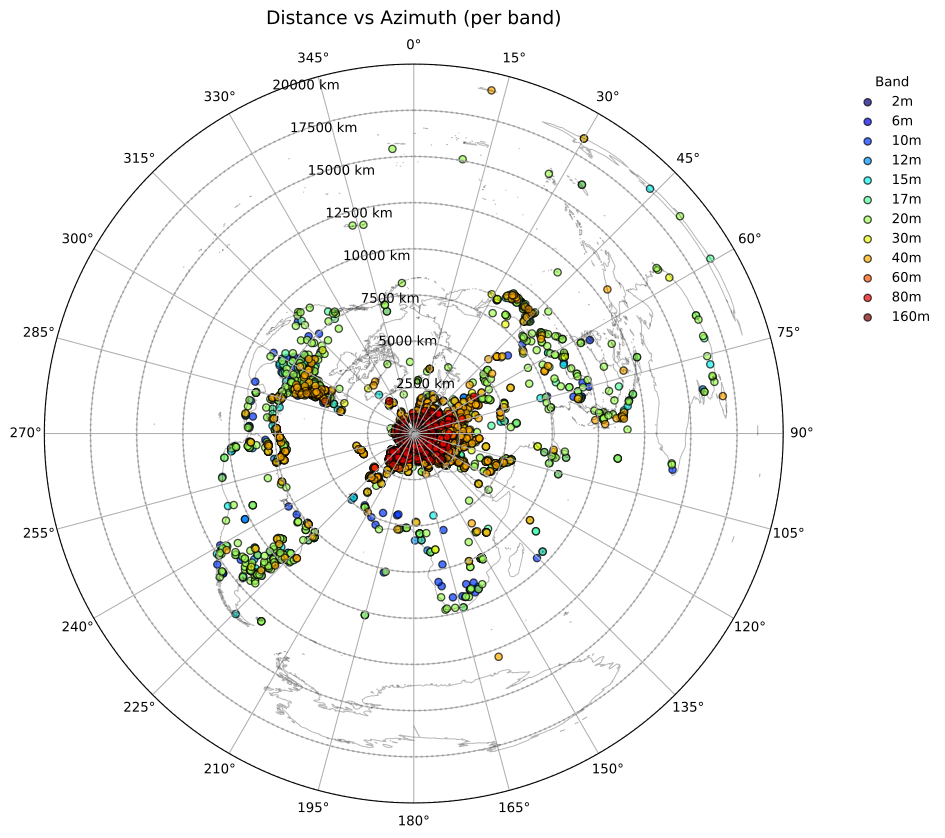
Distance versus azimuth
This diagram shows the distance I’ve covered versus the azimuth of the contact, separated by band. The map I use is an azimuthal equidistant projection with my QTH in the centre.
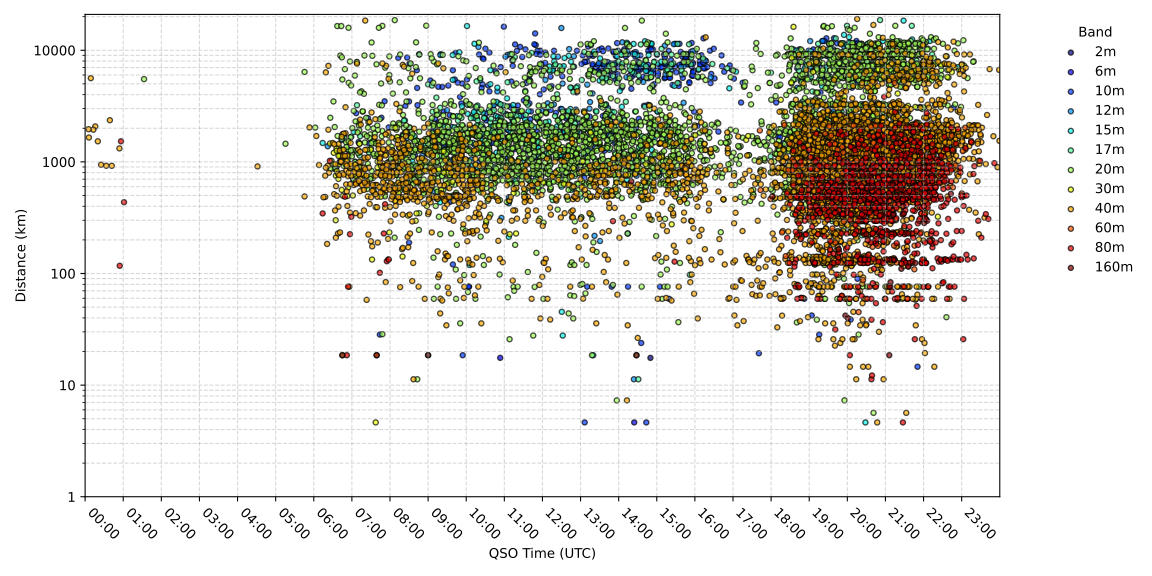
QSO time versus distance
This diagram shows my QSOs plotted in QSO time versus distance of the contact. The vertical scale is logarithmic so contacts nearby can be distinguished from far distant contacts.
Shortest and longest distance record per band and mode
| MODE | 160m | 80m | 60m | 40m | 30m | 20m | 17m | 15m | 12m | 10m | 6m | 2m |
|---|---|---|---|---|---|---|---|---|---|---|---|---|
| DATA | 1028 km IZ5BYH JN53FQ 1045 km F5UJQ IN94LI | 794 km IK2DUW JN45NO 4419 km 7Z1WW KL91NT | 1938 km SV1CQN KM08QO 1938 km SV1CQN KM08QO | |||||||||
| FM | 17 km PI4YSM JO32EM 17 km PI4YSM JO32EM | |||||||||||
| FT8 | 0 km PH0WAW JO32BL 1216 km OH0Z JP90xi | 0 km PA3DNA JO32BL 3826 km RA9LAN MO36 | 45 km PG7R JO22RL 5099 km VE1YX FN74 | 4 km PC9F JO32BM 19045 km ZL7IO AE16RB | 4 km PA9RW JO32BM 16207 km VK2WN QG61 | 0 km PA8KW JO32BL 18603 km ZL3RIK RE66GK | 11 km PA7ZZ JO22XL 18638 km ZL4TT RE54LV | 4 km PA8KW JO32BM 18417 km ZL2BX RE68KR | 11 km PA7ZZ JO22XL 12116 km CE3MRO FF46PG | 4 km PC9F JO32BM 16256 km FK8HM RG37FS | 4 km PC9F JO32BM 1952 km CT1EHX IM67 | |
| JT65 | 1557 km EA1EAS IN70FW 2118 km RK3DSW KO95ft | 1698 km IW8PQ JM78 2630 km RX4CD LO22QH | ||||||||||
| JT9 | 115 km PE4BAS JO33JK 115 km PE4BAS JO33JK | 115 km PE4BAS JO33JK 1752 km UA1AOS KP50 | 1140 km YU2LSD JN96 3561 km RA9CUU MO17 | 668 km G8AFN IO80 11903 km LW5DR GF01 | ||||||||
| MFSK | 41 km PA3FYG JO22SI 41 km PA3FYG JO22SI | 11 km PA7ZZ JO22xl 1539 km OH6BA KP21OT | 25 km PA7HPH JO22XG 3051 km EA8BBJ IL39GD | 760 km F5OIH JN06 760 km F5OIH JN06 | 36 km PA75DX JO32HI 11786 km YC3COY OI62IM | 1938 km SV1CQN KM08QO 5790 km TR8CA JJ40ql | 195 km DJ2TG JO31UA 15825 km VK5GR PF95ID | 1718 km LZ2VQ KN23IF 10197 km PY5QW GG54FO | ||||
| PSK | 791 km F4HER JN06CL 791 km F4HER JN06CL | |||||||||||
| RTTY | 2116 km 3V8LL JM53IR 2116 km 3V8LL JM53IR |
When the minimum and maximum are equal, only one QSO has been made and confirmed on the band/mode combination. Because gridsquares can be logged as either 4 or 6 characters, the measured distances—calculated from the centres of the squares—are approximate. Depending on the grid precision used, the actual distance between two stations may vary by a few kilometres for 6‑character squares, or significantly more for coarser 4‑character squares.
The graphs and table on this page are generated by analysing my LoTW logbook. The ARRL’s LoTW does not record separate sub‐modes and combines sub‐modes as MFSK or DATA. Sub‐mode FT4 is grouped together with other modes like e.g. Olivia and Contesta as MFSK and JS8 is grouped together with other data modes as DATA.