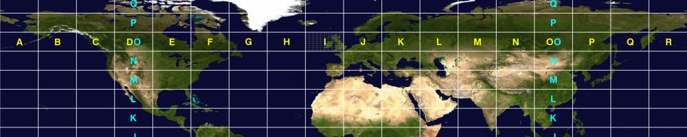
Maidenhead locator
Grid squares explained
The Maidenhead locator system, also called grid squares or QTH locator, describes a position on earth with a short combination of letters and digits. It was adopted at a meeting of VHF managers in Maidenhead, England, in 1980 and is now used worldwide. My own QTH in Zwolle is in grid square JO32.
Table of Contents
How it is built up
The world is divided step by step into ever smaller rectangles. Each pair of characters gives longitude first, then latitude.
| Characters | Name | Values | Size | Approx. size in the Netherlands |
|---|---|---|---|---|
| 1–2 | Field | A–R | 20° × 10° | 1350 × 1110 km |
| 3–4 | Square | 0–9 | 2° × 1° | 135 × 111 km |
| 5–6 | Subsquare | a–x | 5′ × 2.5′ | 5.6 × 4.6 km |
| 7–8 | Extended square | 0–9 | 30″ × 15″ | 560 × 460 m |
Subsquare letters are often written in lower case (JO32bm), but upper case is just as valid.
Calculating your locator
Start from your longitude and latitude in decimal degrees, with east and north positive.
- Add 180 to the longitude and 90 to the latitude, so both are positive.
- Field: divide the longitude by 20 and the latitude by 10. The whole numbers give the letters, counting A = 0.
- Square: take the remainder of the longitude (after dividing by 20) and divide by 2; take the remainder of the latitude (after dividing by 10). The whole numbers are the digits.
- Subsquare: take what’s left of the longitude within the square and divide by 5⁄60 (5 arc minutes); do the same for the latitude with 2.5/60. Count from a = 0.
For example, Zwolle at roughly 52.51° N, 6.09° E gives 186.09 and 142.51. Dividing gives field J (9) and O (14). The remainders 6.09 and 2.51 give square 3 and 2. That makes JO32.
Of course there are plenty of online tools that do this for you, such as the QTH locator map by K7FRY.
Grid squares in the Netherlands
The Netherlands spans nine grid squares, all in field JO. The borders of the squares follow lines of longitude and latitude, not provinces, so check your own position if you live near one.
| Square | Includes, for example |
|---|---|
| JO11 | Vlissingen, Middelburg, Goes, Terneuzen |
| JO20 | Maastricht, Heerlen |
| JO21 | Rotterdam, Breda, Tilburg, Eindhoven, ’s‑Hertogenbosch, Nijmegen, Arnhem, Roermond |
| JO22 | Amsterdam, The Hague, Utrecht, Haarlem, Amersfoort, Lelystad, Apeldoorn, Den Helder |
| JO23 | Leeuwarden, Harlingen, Texel, Terschelling |
| JO30 | Vaals (only a small corner of the country) |
| JO31 | Venlo, Doetinchem |
| JO32 | Zwolle, Deventer, Enschede, Hengelo, Assen, Emmen |
| JO33 | Groningen, Delfzijl |
Where it is used
- FT8 and FT4 send a four‐character locator with a CQ, which is how WSJT‑X can show distance and direction straight away.
- VHF, UHF and microwave contests usually score by distance, so they use the six‐character locator.
- Awards such as the ARRL’s VUCC are based on the number of grid squares worked on VHF and higher.
- Logbooks store the locator in the GRIDSQUARE and MY_GRIDSQUARE fields (see ADIF in a nutshell), which is what my QSO distance charts are based on.